Introduction To Manaslu and Annapurna Trek with Tilicho Lake In Nepal
The Manaslu and Annapurna Trek with Tilicho Lake (passing Thorung La Pass) is one of Nepal’s most beautiful hikes. This trek combines the Manaslu Circuit and the Annapurna Circuit treks into one. This journey will begin in the Manaslu region and end in Pokhara.
The Manaslu and Annapurna Trek with Tilicho Lake takes you to the Manaslu region’s tranquil valley as well as the holy Muktinath Temple. You’ll also be passing across Thorung La Pass, one of the world’s highest passes.
Tilicho Lake, a freshwater lake located at the greatest elevation of 4949 meters above sea level, is one of the trek’s key features. Throughout the walk, you will travel through breathtaking scenery. You will not only see magnificent landscapes, but you will also meet incredible people of many ethnicities who live in peace.
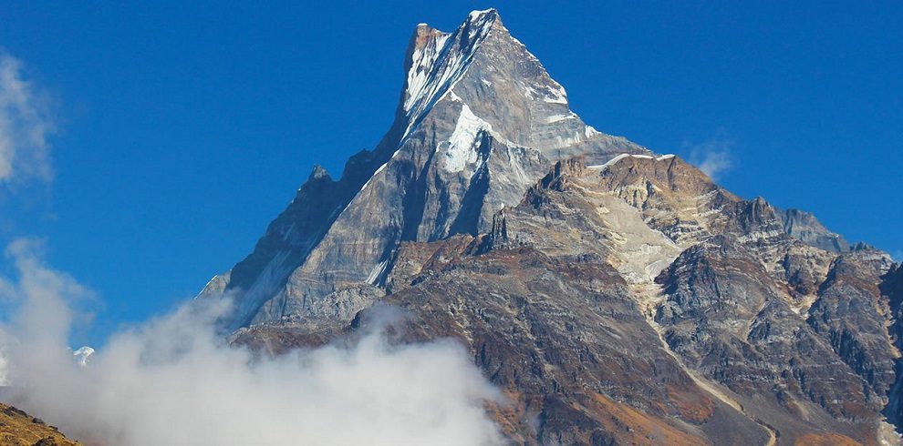
The Larke pass (5160 m) is a long and distinctive pass in Nepal, with amazing views of the surrounding mountains from the top. Until the sixteenth century, the Manaslu region was part of the Tibetan dominion.
The Tibetan influence on the upper Manaslu route has its own way of life, trade, clothing, festivals, and more. Climb from Pokhara’s sub-tropical environment to Thorung La (5,416 m), the world’s highest pass, and the Tibetan-influenced desert-like Kaligandaki Valley.
There are also various waterfalls and lakes that can be found. You’ll be at the base of Ruchhe Waterfall, the highest in the Annapurna Trekking route. In Tatopani, you may also enjoy hot springs.
Highlights Of Manaslu and Annapurna Trek with Tilicho Lake In Nepal
- The Manaslu Panorama and the Larke Pass.
- Tibetan Buddhist monasteries and culture.
- Manang’s Tilicho Lake has breathtaking beauty.
- The Thorong La Pass connects Muktinath with Jomsom through the Kali Gandaki valley.
You may also Visit Nar Phu Valley Trek-Cost, Distance, Itinerary, In Nepal – 19 Days
Overview Of Manaslu and Annapurna Trek with Tilicho Lake
- In Manaslu and Annapurna Trek with Tilicho Lake, you’ll see secluded communities in the Manaslu region and the world’s highest freshwater lake, Tilicho. You’ll also visit the holy temple Muktinath and cross one of the world’s highest passes, Thorung La Pass.
- Muktinath is a sacred shrine where pilgrims from all over the world come to seek redemption. You’ll also be able to tour Mustang’s apple orchards and indulge in apple pie and Apple Brandy, popularly known as Marpha.
- The Manaslu and Annapurna Trek with Tilicho Lake will take you to green hills, breathtaking mountain views, Nepal’s desert, multiple waterfalls, the world’s deepest gorge, Kaligandaki, orchards, lakes, glaciers, and many more other natural beauties.
Itinerary
Meet our agent and transfer to the hotel upon arrival at Kathmandu's Tribhuvan International Airport. After checking in, receive a briefing on the tour and spend the evening at leisure.
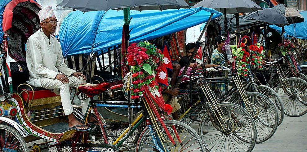
After breakfast, we'll go on a guided tour of Kathmandu's most important historical and spiritual sites. UNESCO World Heritage Sites include the historic Durbar Square, the sacred Hindu temple of Pashupatinath, the well-known 'Monkey Temple' (Swayambhunath), and the Buddhist shrine (Bouddhanath), which is one of the world's most largest stupas. At Himalayan Glacier's office in Thamel at midday, there will be a brief pre-trip group discussion followed by hike preparation. In Kathmandu, spend the night.
We left early this morning for Sotikhola. We get sights of the Nepalese farmland as well as mountain scenery during the trip. From Kathmandu to Dhading Bensi, the district headquarters of Dhading (1050m), we will be driving on a paved road, while the drive from Dhading Bensi to Arughat will be on a rocky road. We continue on to Sotikhola after passing through Arughat, a prominent town in the region. Spend the night in Soti Khola.
We travel through the lovely Sal forests after crossing the bridge, then climb onto a ridge overlooking the Budhi Gandaki's tremendous rapids. On a steep, rocky trail clinging to the edge of a cliff, we reach Khursane, where the rough trail snakes its way up and down, past two tropical waterfalls. It ultimately descends and passes through a few rice terraces before ascending and around to Labubesi, a Gurung village. We continue climbing behind a rocky outcropping, where the valley widens and the Budhi Gandaki meanders between vast gravel bars. We stroll among rounded stones before ascending over a side hill after dropping to the sandy riverbed. To reach Machha Khola village, we return to the river and cross another suspension bridge. Machha Khola is where you'll spend the night.
The narrow trail passes through several minor ups and downs before crossing the Tharo Khola and arriving in Khorlabesi. We arrive at a little Hotspring in Tatopani after a few more ascents and descents. We ascend over another mountain from the hot spring and then cross the Budhi Gandaki on a suspension bridge. At this point, we climb a wide, well-built stairway to Dobhan, then cross a landslide and cross a ridge. We climb stone stairs after passing a suspension bridge over the Yaru Khola, then drop to the river and climb more stone stairs to Tharo Bharyang. We rise over a mountain, hike along the river, and then climb into the village of Jagat after crossing the west bank of the Budhi Gandaki. Jagat is where you'll spend the night.
Today's hike begins with a rise over a stony ridge to Salleri, followed by a descent to Sirdibas. As the trail ascends to Ghatta Khola, the valley opens slightly. We continue trekking upstream to Philim, a big Gurung village, where we cross a long suspension bridge. The trail heads north right above the village's lowest dwelling, staying on a fairly level trail as it passes through millet fields on its way to Ekle Bhatti. The trail now reaches a narrow, unpopulated gorge. We descend to the grassy land slopes at this point, cross the Budhi Gandaki, then wander along the west bank for a bit before crossing to the east bank and returning. The valley widens as we progress along the trail, and we pass through bamboo groves on our way to the Deng Khola. We arrive in the little settlement of Deng after crossing the Khola. Deng, Deng, Deng, Deng, Deng, Deng, Deng,
We cross the Budhi Gandaki and rise to Rana village at 1910m after a brief hike past Deng. We climb a little from the bridge to join a Bhi track, then proceed west into the Budhi Gandaki valley. The trail also passes through woodlands and mani before turning towards a Ghap-shaped corner. We pick the path through Prok village despite the fact that there is another option. A stunning view of Siring Himal can be seen from Prok village's viewpoint. We cross the Budi Gandaki numerous times today and pass by a few gompas along the way. Through a deep woodland, the trail follows the river upstream. The forest gets less dense and the track is great again after crossing the river at a spectacular location when it thunders down a tight gorge. The pleasant hike continues, and we arrive in Namrung after a final difficult ascent. Namrung is where you'll spend the night.
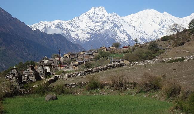
Namrung village provides a good vantage position towards Siring and Ganesh Himal, as well as Mt. Himal Chuli in the south. We continue to rise steeply through the forest until we reach Lihi, a lovely town with many chortens and barley terraces. The trail descends and traverses Simnang Himal's side valley, with Ganesh Himal constantly nearby. Before arriving in Sama Village, we pass via the villages of Sho, Lho, and Shyala. From Lho village, we have spectacular views of Mt. Manaslu and visit the famed Ribung Gompa. We will be surrounded by high mountains to the left, such as Himal Chuli and Peak 29 (Ngadi Chuli), Manaslu and big glaciers straight ahead, and more snow summits to the right, with Ganesh Himal at the far end. The journey today concludes in Samagaon, where we will spend the night.
We stay at Samagaon for the day to relax and acclimate. Today, we learn about the fascinating Sherpa culture. Thousands of mani stones with Buddhist texts and images, as well as Sherpa women dressed in traditional clothing and decorations, are a sight to behold. A historic Gompa (Pungyen Gompa), a monastery with spectacular views of the glacier, sits on a small hill near Samagaon town. Pungyen means bracelet, which is a fair description of the two peaks. It is named after Manaslu. A year after the first unsuccessful Japanese effort to ascend Manaslu, it was demolished. The villagers believed that the ascent had upset the gods, and when the Japanese returned a year later, they were met with such fierce opposition that they were forced to abandon their endeavor. In 1959, they were eventually successful. Samagaon is where you'll spend the night.
We'll descend to the Budhi Gandaki River, which has veered north and follow it to a bridge across a side stream today. The Manaslu Base Camp is reached through the trail to the left. As the valley widens, the Larkya la Trail passes multiple mani walls. It's a short walk that takes you through Kermo Kharka's juniper and birch woodlands on a shelf above the river. We descend off the ledge, cross the Budhi Gandaki on a wooden bridge, and ascend steeply to a point between two river forks. A big white kani may be seen from a stone arch. Finally, we reach Samdo after crossing through the kani. Samdo is where you'll spend the night.
Another day has been set aside to allow for proper acclimatization. For now, we have two choices. A climb up the valley just behind Samdo village is an option that we highly recommend. This trip will take us to one of Tibet's trade passes, where we will be able to see Mt. Manaslu as well as other Himalayan ranges such as Simrang, Hiunchuli, Ngadi, Larkye Peak, Cheo, and probably Kang Guru. We pass through many seasonal herding towns known as doksas on our way to these vistas and see some lovely mountain birds such as the Lophophorus (Nepal's national bird), Lammergeyer, and Himalayan Griffin soaring high above us. A trek to the Gya La ('big pass') to the north of Samdo, a more commonly used commerce route to Tibet, could be another possibility for today. However, because this is a longer hike (the entire day), it may be exhausting. Samdo is where you'll spend the night.
Even today, we go down the cliff's edge, cross the wooden bridge over the Budi Gandaki, and begin ascending. We go around the valley of the Salka Khola and climb up to the stone guest house (4450 m), which is not a lodge but a form of shelter called Dharmshala, also known as Larke Phedi, after crossing two streams and seeing the Larkya Glacier. Today's short trek also allows for plenty of acclimatization and relaxation in the afternoon. Dharmashala is where you'll spend the night.
We reach a valley on the north side of the Larkya Glaciers after a short ascent, from whence we can see Cho Danda and Larkya Peak. Finally, we traverse glacial moraines and begin a steady ascent that only becomes harder in the final stretch of the pass. The Himlung Himal, Cheo Himal, Kangguru, and the massive Annapurna II can all be seen from the pass. It's a long day to Bimtang than normal, but walking through these low plains with the dusk mist rolling in and Mt. Manaslu looming nearby is an incredible experience. Bimthang is where you'll spend the night.
Mt. Manaslu, Lamjung Himal, Himlung Himal, and Cheo Himal can all be seen from a ridge in Bimthang. We continue downhill and cross a high meadow (Sangure Kharka) before crossing the Dudh Khola on a bridge. We travel through a rhododendron woodland and along a narrow valley trail until we reach Karche, the region's highest cultivated area at 2785 meters. We pass through farmland before ascending a steep mountain. At 2580m, the trail descends in a large, sweeping arc from the mountain to the riverbank. The settlement of Gho is a short distance away. We may spend the night at Gho due to yesterday's exhaustion, but better lodges are available in Tilije, therefore Himalayan Glacier suggests that we stay there. Tilije Village is where you'll spend the night.
From here, we'll be on the traditional Annapurna trail. We drop from Tilije first, then pass a suspension bridge and ascend to Thoche settlement. Following that, we take a very straight path to Bagarchhap village, where we come across a Power House for power production. We pass through a few high forested ridges, as well as multiple landslides, on our way from Bagarchaap to Chame. Remember to gaze up, as you'll be rewarded with breathtaking vistas of the Lamjung Himal, Annapurna II, and Annapurna IV (7,525m/24,688ft) Himalayan peaks. Chame is where you'll spend the night.
The stunning curved rock face, rising 1500m from the river, is reached through a steep, narrow road through a dense forest. You'll be surrounded by breathtaking Himalayan peaks as the terrain begins to open up. In Pisang, spend the night.
When you reach the upper Manang region, you'll notice a change in the environment and vegetation. The harsher environment is created by the cold, dry climate. In addition, we get to see breathtaking views of the Himalayan peaks. In Manang, spend the night.
We leave Manang through the western gates and descend the slope to the river. We cross the river and continue going towards Khangsar village on the south side of the river through coniferous woodland. We continue on from Khangsar to Siri Kharka, passing a monastery along the way. The uphill hike may be difficult, but we will be accompanied by Gungang Himal and Mt. Chulu in the background. Siri Kharka is where you'll spend the night.
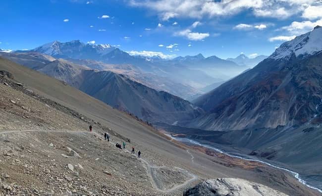
It's generally downhill from Siri Kharka to Tilicho Base Camp, but there are several landslide spots that can be risky. The trails aren't tough to walk, but they are extremely narrow. The trail runs right through the heart of the landslide zone. The trail's rock formations are rather stunning. Tilicho Base Camp is where you'll spend the night.
The path ascends from Tilicho Base Camp via moraine ridges and grassy slopes to some huge switchbacks carved into the mountainside. Then we come to the watershed. On the other side is Tilicho Lake, a vast magnificently placed lake tucked at the foot of Tilicho Peak's north face, part of the snowy wall dubbed "The Great Barrier" by a 1950 French expedition team. The French team's commander, Maurice Herzog, dubbed Tilicho Lake "The Great Ice Lake." The Lake is also significant to Hindus, as it is mentioned in one of their holiest writings, The Ramayan. We return to Siri Kharka by retracing our steps. Siri Kharka is where you'll spend the night.
This path from Siri Kharka to Yak Kharka, which is on the major circuit trail, avoids backtracking to Khangsar and Manang when returning from Tilicho Lake. We descend from Siri Kharka toward Thare Gomba and arrive at a trail intersection in just a few minutes. We turn left again and walk for a while till we reach Old Khagsar. Except for the odd herders and during festival periods, Khangsar is deserted. Out of Khangsar, we follow the rock wall north. We continue walking till we reach the Thorang Khola valley's seasonal bridge. We cross the river to the east band and climb to a plateau for a bit. We continue walking till we reach Yak Kharka. Yak Kharka is where you'll spend the night.
It's a steep trek from Yak kharka to Thorang Phedi. We arrive in Ledar village after a short walk across a suspension bridge. We start climbing again, this time towards Thorang Phedi, which is only about an hour's walk from Leder. We are rewarded with some of the best vistas of the Himalayan ranges, including Mt. Gundang, Mt. Syagang, Thorung Peak, and Mt. Khatungkan, on this excursion. Thorang Phedi is where you'll spend the night.
We continue up towards Muktinath today, crossing the famed Thorung La Pass (5,416m/17,769ft). The journey to the pass is thrilling, and it serves as a transition from one major Himalayan valley to another. The Kalai Gandaki River may be seen far below to our west. The descent from the pass is moderate at first, but it quickly becomes steeper and follows the valley's south side. We cross a suspension bridge, continue walking through the famed Muktinath temple, and arrive in Muktinath/ranipauwa village. The majestic Dhaulagiri and Annapurna ranges may be seen from here. Then we're on our way to Jomsom. Jomsom is where you'll spend the night.
Your trekking team will assist you with your luggage to the airport after breakfast and bid you farewell for the last time. Our contact in Jomsom will handle all of your flight arrangements from Jomsom to Pokhara. When you get to Pokhara, you must check into your accommodation. Then you can either relax or take a stroll through Pokhara's gorgeous streets. Pokhara is where you'll spend the night.
Drive to Kathmandu in the early morning aboard a tourist bus, taking in the riverside views, terraced farms, and some small communities along the way. When you arrive in Kathmandu, you check into your hotel. You can spend the rest of the day relaxing, catching up on some last-minute shopping, or exploring any Kathmandu sights that interest you. Dinner will be served in the evening to commemorate your great journey. In Kathmandu, spend the night.
Includes/Excludes
Includes
- B&B accommodation is available in Kathmandu and Pokhara.
- All lodging and food during the journey.
- All ground transportation in a private car according to the schedule Professional and experienced guide, porter, and driver.
- Salary, insurance, lodging, and meals for all employees (driver, guide, and porter).
- All government taxes, including TIMS and ACAP, are included in the price.
- Flight: Jomsom – Pokhara.
- Transportation: (Kathmandu – Soti Khola) & (Pokhara – Kathmandu).
- Standard Medical Kit.
Excludes
- All personal expenses, such as alcoholic beverages, phone calls, internet access, and laundry, are included.
- Gratuities to the guide, porter, driver, and other service personnel.
- Fares for international flights.
- Fees for Nepal visas.
- Insurance for travel.
- Charges for emergency evacuation and rescue.
Manaslu and Annapurna Trek with Tilicho Lake- 25 Days
This is a hike that is moderately tough. The difficulty of the Manaslu Circuit Trek is mostly determined by the trekker’s physical condition. The Manaslu Trek is one of Nepal’s most arduous hikes, taking you through remote Himalayan villages. It is one among Nepal’s off-the-beaten-path treks.
The cost of a 7-day Tilicho Lake trek in Nepal is approximately NPR 24,000 (approximately). Day 2: Drive with the Jeep from Besi Sahar to Chame.
The entire glacier from the Tilicho peak’s slope is the lake’s source. From December through April, the lake is frozen.
Drive from Kathmandu to Pokhara on the first day. Drive from Pokhara to Jomsom on Day 2. Day 3: Drive from Jomsom to Muktinath via Kagbeni, then return to Thini and explore the Dhumba Lake area. Day 4 & 5: Drive to Namakhu, the Tilicho Lake Base Camp, and hike to the Lake before returning to Marpha.