If you dream of an authentic Himalayan trekking adventure that trades crowds for raw wilderness, commercial teahouse rows for genuine mountain culture, and well-worn tourist paths for a true sense of discovery — the Manaslu Circuit Trek 15 Days with TrekkingKey is your answer. Circling the world’s eighth-highest peak, Mount Manaslu (8,163m), through the restricted zone of western Nepal, this route is widely regarded as one of the most spectacular and least-crowded circuit treks in the entire Himalayan world.
The journey takes you from the subtropical river valleys of the lower Budhi Gandaki gorge — where Hindu villages cling to terraced hillsides — all the way through dense rhododendron and pine forests, high-altitude Tibetan Buddhist settlements adorned with prayer flags and mani walls, sweeping glacial meadows, and ultimately over the legendary Larkya La Pass (5,106m) — the dramatic high-altitude crown of the entire circuit. Unlike the famous Everest Base Camp and Annapurna Circuit treks, the Manaslu region remains a restricted area with strict access controls, ensuring that only genuine adventurers experience its untamed trails, unspoiled nature, and deeply preserved Tibetan culture.
TrekkingKey’s carefully designed 15-day itinerary takes you from Kathmandu by private jeep to Machhakhola, then north through the spectacular Budhi Gandaki valley — through the memorable settlements of Jagat, Deng, Namrung, Lho, and Samagaun — with a full acclimatization day before pushing to Samdo, Dharamsala, and finally over Larkya La into the Annapurna region. The descent through Bimthang and Dharapani completes a full circuit — no trail repeated, every day revealing a completely different Himalayan world. A private jeep returns you to Kathmandu in comfort.
This is the Manaslu Circuit Trek — a journey for those who want their Himalayas raw, cultural, and genuinely unforgettable. With TrekkingKey’s local expertise, experienced licensed guides, transparent all-inclusive pricing, and unwavering focus on your safety, every step of this extraordinary adventure is in expert hands.
QUICK FACTS
| Duration | 15 Days |
| Max Altitude | 5,106m / 16,752ft (Larkya La Pass) |
| Difficulty | Moderate to Strenuous |
| Trek Distance | ~177–180 km / 110–112 miles |
| Daily Walking | 4–9 hours |
| Start / End | Kathmandu, Nepal |
| Transport | Private Jeep Kathmandu–Machhakhola & Dharapani–Kathmandu |
| Best Season | Spring (Mar–May) & Autumn (Sep–Nov) |
| Accommodation | 3-Star Hotel in Kathmandu + Teahouses on trail |
| Group Size | Min. 2 – private & group departures available |
-
bus
-
1-30
-
5106 m
-
1
-
79
- Cross the legendary Larkya La Pass (5,106m) — the crowning high-altitude achievement of the entire circuit, with panoramic views of Himlung Himal, Cheo Himal, Kang Guru, and Annapurna II
- Trek around Mount Manaslu (8,163m) — the world’s eighth-highest peak — on a complete circuit with no trail repeated
- Experience the least-crowded major circuit trek in Nepal — the restricted area permit system ensures genuine Himalayan solitude
- Explore the culturally rich Tibetan Buddhist village of Samagaun, with the magnificent Kargya Chholing Monastery and Pungyen Glacier
- Visit the ancient Gompa at Lho village, home to over 150 children studying Buddhist philosophy, with jaw-dropping close-up views of Manaslu
- Trek through the entire length of the dramatic Budhi Gandaki gorge — one of Nepal’s most spectacular river valleys
- Encounter the cultural transition from Hindu mid-hill communities to high Tibetan Buddhist settlements as you ascend
- Descend through the Annapurna region after Larkya La — experiencing two of Nepal’s greatest wilderness areas in a single trek
- Walk the ancient trans-Himalayan caravan trade route between Nepal and Tibet, still alive in the memories of local villagers
- Experience extraordinary wildlife — Himalayan thar, blue sheep, rare snow leopard, sunbirds, eagles, and Himalayan pheasants in their natural habitat
- Cross dramatic suspension bridges over the roaring Budhi Gandaki and Marsyangdi rivers throughout the circuit
- Enjoy the spiritual warmth of Samagaun — where monks conduct puja ceremonies for expedition teams before Manaslu summit attempts
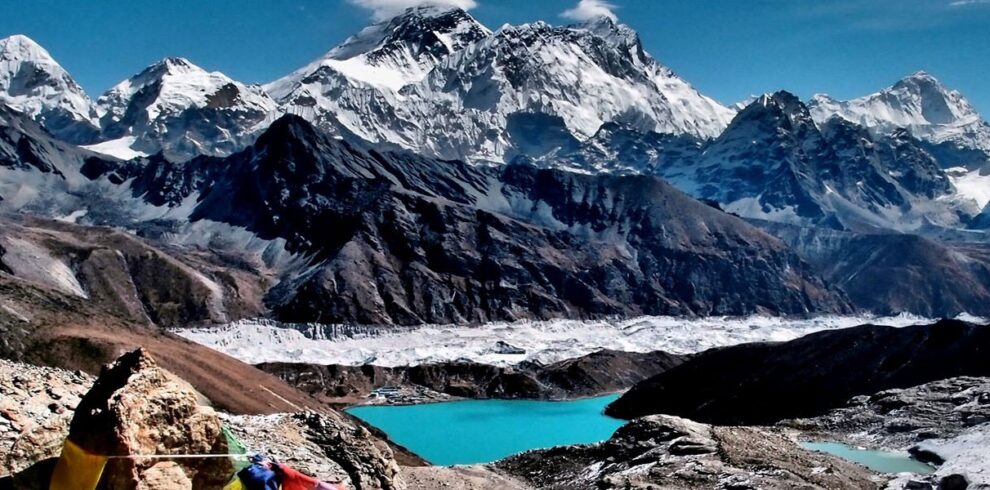
- Stand at Birendra Taal (glacial lake) for a silent, pristine encounter with the high Himalayas
- Complete a true Himalayan adventure requiring genuine fitness, determination, and rewarding you with an unmatched sense of achievement
Welcome to Kathmandu — Nepal's ancient, vibrant capital and the gateway to the Himalayas! A TrekkingKey representative will be waiting to greet you at Tribhuvan International Airport and transfer you to your hotel in the heart of Thamel. This extraordinary medieval city — with its UNESCO World Heritage temples, incense-scented alleys, and the constant energy of travellers from across the globe — is the perfect introduction to your Manaslu adventure. Spend the afternoon resting or exploring Thamel's lively trekking shops, restaurants, and cultural landmarks. In the evening, your TrekkingKey trek leader will brief you on the full itinerary, permits, safety protocols, and gear requirements. End the night with a traditional Nepali welcome dinner.
Accommodation: 3-Star Hotel | Meals: Welcome Dinner
After breakfast, your TrekkingKey team accompanies you on a guided tour of Kathmandu Valley's most significant heritage sites. Begin at Swayambhunath Stupa — the famous 'Monkey Temple' perched atop a hilltop offering sweeping panoramas of the entire Kathmandu Valley. Continue to the sacred Hindu pilgrimage site of Pashupatinath Temple on the banks of the Bagmati River — one of the holiest Shiva temples in the world — and then to the magnificent Boudhanath Stupa, one of the largest stupas in Asia and the spiritual heart of Kathmandu's Tibetan Buddhist community. If time allows, explore the medieval durbar squares of Basantapur, Patan, or Bhaktapur. In the afternoon, your TrekkingKey guide will assist with any last-minute equipment needs in Thamel, confirm all Manaslu restricted area permits, and prepare you fully for tomorrow's departure.
Accommodation: 3-Star Hotel | Meals: Breakfast
An early start as your TrekkingKey private jeep departs Kathmandu heading northwest along the Prithvi Highway. The scenic drive winds through the green hills of central Nepal, following the Trishuli River through charming Nepalese highway towns — Malekhu, Kurintar, Dhading — before turning north towards Arughat and the Budhi Gandaki valley. The mountain landscape progressively opens up as you approach the Manaslu region — distant views of Ganesh Himal and the ice-clad mass of Manaslu itself begin to appear on the northern horizon. After navigating the winding mountain roads beyond Soti Khola, the jeep reaches Machhakhola — your trailhead village — in the early evening. Settle into your teahouse, meet your porter crew, enjoy dinner, and prepare for the first day of trekking tomorrow.
Drive: ~8–9 hrs | Accommodation: Teahouse | Meals: Breakfast & Dinner
The first day of trekking plunges you immediately into the wild heart of the Budhi Gandaki gorge. From Machhakhola, cross the river on a suspension bridge and begin the gradual climb through forest and terraced farmland. The trail passes through the natural hot spring village of Tatopani — a wonderful spot for sore legs — before the gorge narrows dramatically and the path becomes more challenging. Cross more suspension bridges over the roaring river, pass through the riverside settlement of Doban, and continue north through increasingly dense forest to the village of Jagat. This checkpoint village marks the entry point into the Manaslu Restricted Area — your TrekkingKey guide completes permit formalities with the local authorities. Jagat was badly damaged in the 2015 earthquake but has been beautifully rebuilt; the warm hospitality of its people, dressed in traditional attire and engaged in rural daily life, makes for a wonderful first evening on the trail.
Walking: ~20km / 6–7 hrs | Accommodation: Teahouse | Meals: All included
Continuing deeper into the Budhi Gandaki gorge, today's trail passes through some of the most spectacular riverside scenery of the entire lower circuit. Cross suspension bridges over the thundering river, traverse narrow cliff-side paths, and walk through dense stands of pine and rhododendron. The trail passes through Filim — a large Gurung village where Buddhist stupas, chortens, and prayer flags mark the transition into the predominantly Tibetan Buddhist cultural zone. After a well-earned lunch stop, the path continues through lush subtropical forest with dramatic mountain views beginning to appear ahead. The village of Deng, perched on a terraced hillside, rewards the day's effort with its warm teahouses and the first truly outstanding views of the snow-capped peaks of the Manaslu massif rising to the north.
Walking: ~20km / 6–7 hrs | Accommodation: Teahouse | Meals: All included
Today the trail begins to climb more consistently as you enter the upper reaches of the Budhi Gandaki valley. From Deng, the path winds through a series of small Tibetan-influenced settlements, crossing log bridges, passing isolated watermills, and traversing basalt rock formations draped with prayer flags. Cross the Serang Khola and navigate the narrow valley walls before the landscape opens into the broader upper valley. Pass through the settlement of Ghap, where mani walls and ancient chortens signal the deepening Tibetan Buddhist cultural influence, and continue through beautiful rhododendron and pine forest before reaching Namrung. This remarkable Tibetan village serves as the gateway to Upper Nupri — a significant cultural entry point where the architecture, dress, and way of life are unmistakably Tibetan. A full circuit of mani walls and prayer wheels around the village is a fitting end to a rewarding day.
Walking: ~19km / 6–7 hrs | Accommodation: Teahouse | Meals: All included
A shorter but deeply rewarding day that brings the extraordinary scale of Mount Manaslu into full, breathtaking view for the first time. From Namrung, the trail climbs along the valley hillside past ancient mani stone walls to reach the ridge above the Pungen Glacier, where the first truly close-up panoramas of Peak 29 (Ngadi Chuli), the Pungen Glacier's lateral moraine, and the sweeping icefields of Manaslu itself appear. The sight stops every trekker in their tracks. Continue to the beautiful village of Lho — home to a significant Gompa where over 150 children receive primary education alongside Buddhist philosophy. The monastery hilltop provides what many trekkers describe as the single finest view of Mount Manaslu available anywhere on the circuit — particularly magnificent at sunrise when Manaslu's twin 'fishtail' summits glow in the morning light. An afternoon of cultural exploration and rest prepares you for the higher altitudes ahead.
Walking: ~11km / 4–5 hrs | Accommodation: Teahouse | Meals: All included
A memorable day of trekking through the wide upper valley with increasingly grand mountain scenery on all sides. From Lho, descend to the Damodar Khola and cross into the broad upper valley, with magnificent views of Ganesh Himal and Himalchuli appearing to the south. Pass through the picturesque village of Shyala before crossing the Numla Khola suspension bridge and climbing gradually through grassy slopes to the Pungyen Gompa viewpoint — offering one of the finest panoramas of Manaslu's south face and the Pungyen Glacier. The trail then descends gently into the wide, open valley of Samagaun — one of the most beautiful and culturally significant villages on the entire Manaslu Circuit. This large, prosperous Tibetan Buddhist community is home to the revered Kargya Chholing Monastery and the Labrang Gompa, where expedition teams receive puja blessings before their Manaslu summit attempts. A stunning and emotionally rich arrival.
Walking: ~8km / 4–5 hrs | Accommodation: Teahouse | Meals: All included
A full rest and acclimatization day at Samagaun — an essential and genuinely enjoyable part of TrekkingKey's Manaslu itinerary before the higher altitude sections ahead. The day is anything but idle. After breakfast, set out on a rewarding acclimatization hike towards the Manaslu Base Camp direction or up to the Pungyen Gompa for stunning glacier and mountain views. Alternatively, explore Samagaun's cultural treasures: the Labrang Gompa and Kargya Chholing Monastery are both extraordinary examples of Tibetan Buddhist architecture and spiritual life. The view of Mount Manaslu (8,163m) from the moraine ridge above the village is arguably the most spectacular mountain panorama on the entire circuit. The surrounding juniper hillsides, rhododendron forest, grassy moorland, and flat bouldery river valley offer varied short walks. Evening brings the opportunity to witness the remarkable puja ceremony conducted by monks for any expedition teams preparing for their Manaslu summit attempt — a genuinely moving cultural experience.
Walking: 1–4 hrs (acclimatization hike) | Accommodation: Teahouse | Meals: All included
A shorter but altitude-gaining day as the trail leaves Samagaun and continues north towards the high-altitude terrain approaching the Tibetan border. Descend to the Budhi Gandaki along the base camp trail before crossing a wooden bridge and climbing steeply to a ridge with sweeping views across the barren, high-altitude landscape. The terrain becomes noticeably more austere here — the subtropical forests of the lower valley are a distant memory, replaced by wide open yak pastures, rocky moraines, and the immense white wall of Samdo Peak ahead. The views of Dharamsala, Manaslu, and the Siachen Glacier are simply magnificent. Samdo itself is a small but welcoming village that once served as an important waypoint on the ancient trans-Himalayan salt caravan trade route between Nepal and Tibet. The villagers maintain their traditional Tibetan Buddhist practices and lifestyle in this remote, high-altitude environment — a profound cultural encounter on the edge of the Tibetan plateau.
Walking: ~8km / 4–5 hrs | Accommodation: Teahouse | Meals: All included
A short but important altitude-gain day that takes you to the highest teahouse camp on the entire Manaslu Circuit — Dharamsala (also called Larkya Phedi) — in preparation for tomorrow's Larkya La Pass crossing. From Samdo, cross the Budhi Gandaki River and begin climbing through barren high-altitude terrain and the Larkya Bazaar ruins before ascending through the broad Pana Danda valley. Grassy slopes give way to glacial moraine as the trail climbs towards the Syacha Khola Valley, with extraordinary views of the Syacha Glacier opening up to the north. The final approach to Dharamsala crosses the terminal moraine of the Larkya Glacier, with the dramatic twin forms of Larke and Naike peaks guarding the high pass visible above. Arrive at Dharamsala in the early afternoon — rest, hydrate thoroughly, eat a nutritious dinner, and set your alarms early. Tomorrow is the biggest day of the entire trek.
Walking: ~7km / 3–4 hrs | Accommodation: Teahouse | Meals: All included
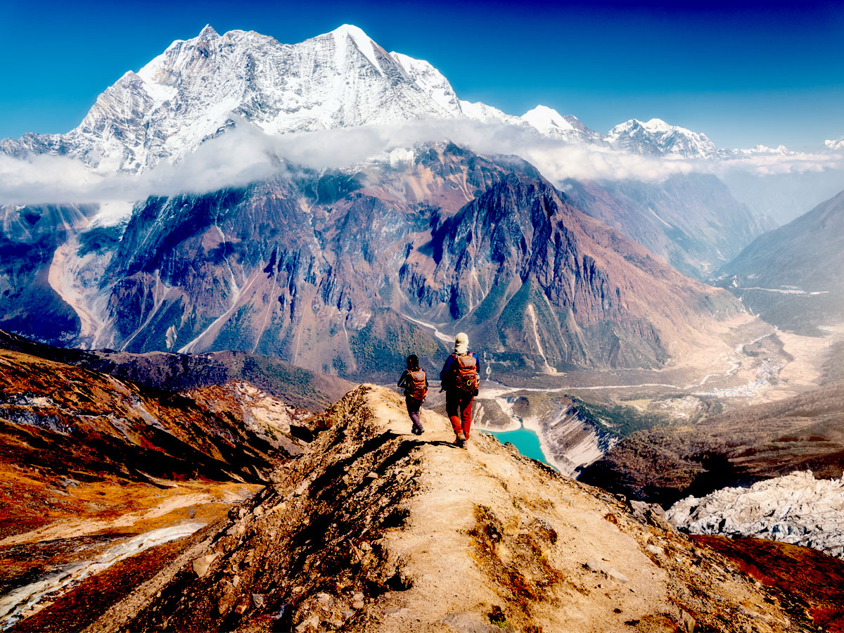
The crown jewel of the entire Manaslu Circuit Trek — the day every trekker will remember for a lifetime. Rise well before dawn (typically 4:00–5:00 AM) to begin the long ascent to Larkya La Pass (5,106m) in the pre-dawn darkness, headlamps lighting the way across glacial moraine, frozen lakes, and ice-dusted rocky terrain. The ascent gains altitude steadily and demands focused effort, strong legs, and a determined mindset. As the sun rises, the high Himalayan panorama around you becomes progressively more extraordinary. At the summit of Larkya La, a breathtaking 360-degree panorama explodes in every direction: the Himlung Pyramid (7,126m), Cheo Himal (6,820m), Kang Guru (6,981m), Gyaji Kung, and the vast ice-fields of Manaslu's northern flanks — and to the south, the first magnificent view of Annapurna II (7,937m). After savouring this hard-earned summit moment, the long descent to Bimthang begins — a dramatic drop of over 1,500 metres through glacial valleys, Dingboche Kharka pastures, and finally the gorgeous high-altitude meadows surrounding Bimthang village. An unforgettable, demanding, triumphant day.
Walking: ~24km / 8–9 hrs | Accommodation: Teahouse | Meals: All included
After the extraordinary exertion of yesterday's Larkya La crossing, today's long descent from Bimthang is both a physical recovery and a feast for the eyes as the Himalayan landscape transitions from glacial high country back to lush mid-mountain forest. From Bimthang, the trail crosses stony glacial terrain and moraine before descending into the dense forest of the lower valley — with magnificent views of Manaslu, Larke, Nadi, and Chuli Himal framing every turn. Pass through Sangura Kharka and Hompuk before reaching the charming village of Karcher, then continue through terraced fields and the beautiful stone-paved trails of Tilje and Gho. The final descent through the Marsyangdi River valley brings you to the chorten-arched gateway of Thonje, through the police checkpoint, and down to Dharapani — a key junction village of the Annapurna Circuit where you rejoin the main trail network. A cold drink and a warm meal at the teahouse marks the completion of the Manaslu circuit itself — a truly historic achievement.
Walking: ~21km / 7–8 hrs | Accommodation: Teahouse | Meals: All included
Your TrekkingKey private jeep is waiting in Dharapani for the long but scenic drive back to Kathmandu. The route follows the Marsyangdi River south to Besishahar, then joins the paved Prithvi Highway for the remainder of the journey through the rolling hills and river valleys of central Nepal. The changing landscape — from steep mountain gorges to terraced farmland to the busy towns of the Kathmandu Valley — provides a wonderful final contrast to the wilderness you have just traversed. Arrive in Kathmandu by evening and transfer to your hotel for a long-awaited hot shower and comfortable bed. In the evening, TrekkingKey hosts a celebratory farewell dinner at one of Kathmandu's finest Nepali restaurants — a fitting and joyful conclusion to 15 extraordinary days. Raise a glass to the Larkya La, to Mount Manaslu's ice-draped summit, and to the remarkable people of the Budhi Gandaki valley.
Drive: ~9–10 hrs | Accommodation: 3-Star Hotel | Meals: Breakfast + Farewell Dinner
Your final morning in Nepal. Enjoy a leisurely breakfast and take time for last-minute souvenir shopping in Thamel — handmade Tibetan crafts, singing bowls, thangka paintings, yak wool products, and Nepalese handicrafts make perfect gifts. TrekkingKey will transfer you to Tribhuvan International Airport with plenty of time before your onward flight. We say farewell with warm hearts, outstanding memories, and the knowledge that you have completed one of the Himalayas' most demanding, rewarding, and culturally rich circuit treks.
Meals: Breakfast | Airport Transfer Included
Transport Note: The drive between Kathmandu and Machhakhola / Dharapani passes through mountain roads that can be subject to seasonal conditions and occasional landslides. TrekkingKey recommends a buffer day in Kathmandu at the end of your trip. All transport is arranged by TrekkingKey in comfortable private jeeps.
Includes
- • All airport and hotel transfers in Kathmandu
- • 3 nights hotel accommodation in Kathmandu (3-star, Bed & Breakfast)
- • All teahouse accommodation during the trek (12 nights)
- • All meals during the trek — breakfast, lunch & dinner, plus fresh fruit each evening
- • Private jeep transport: Kathmandu–Machhakhola and Dharapani–Kathmandu
- • Experienced, English-speaking licensed TrekkingKey guide with all food, accommodation & insurance
- • Porter service (1 porter per 2 trekkers) with all food, accommodation & insurance
- • Manaslu Restricted Area Permit
- • Manaslu Conservation Area Permit (MCAP)
- • Annapurna Conservation Area Permit (ACAP) — for the Dharapani section
- • Guided Kathmandu Valley city tour by private vehicle
- • TrekkingKey duffel bag for use during the trek
- • TrekkingKey company t-shirt
- • First aid kit with pulse oximeter — oxygen saturation and heart rate checked twice daily
- • Emergency helicopter evacuation coordination (paid by your travel insurance)
- • Government taxes and all administrative fees
- • Farewell dinner in Kathmandu
- • 24/7 TrekkingKey support
Excludes
- • International flights and Nepal visa fees (USD 50 for 30-day visa on arrival)
- • Personal travel and medical/evacuation insurance (mandatory — must cover altitude up to 5,500m)
- • Personal trekking gear and equipment
- • Lunches and dinners in Kathmandu (except included welcome and farewell dinners)
- • Tips for guides, porters, and driver (recommended: 10–15% of trek cost)
- • Personal expenses — hot showers, Wi-Fi, battery charging, cold/hot drinks, alcoholic beverages
- • Sightseeing / monument entrance fees (~USD 30 per person for Kathmandu Valley tour)
- • Optional equipment rental: sleeping bags, down jackets, walking poles (USD 10 each), microspikes and gaiters (USD 15)
- • Laundry, telephone, and personal medical kit
- • Extra nights in Kathmandu due to flight delay, road closure, or personal reasons
DIFFICULTY & FITNESS
The Manaslu Circuit Trek is rated moderate to strenuous — making it one of Nepal’s more demanding major treks, though one that does not require technical climbing experience. It is ideally suited for trekkers with previous high-altitude hiking experience and solid cardiovascular fitness. The trek involves daily walks of 4–9 hours over rough, remote terrain, including steep ascents and descents, river crossings, and high-altitude passes. The remoteness of the region — with limited medical facilities and rescue services — makes thorough physical and mental preparation essential.
The highlight and most demanding moment of the trek is the Larkya La Pass crossing (5,106m) on Day 12 — a long, early-start day of up to 9 hours that requires excellent endurance, prior acclimatization, and determination. TrekkingKey’s carefully designed itinerary with a full acclimatization day at Samagaun ensures your body is properly prepared for this challenge.
TrekkingKey recommends beginning fitness preparation 8–12 weeks before departure. Focus on cardiovascular endurance (hiking, running, cycling, swimming), leg strength (squats, lunges, step-climbs), core stability, and backpack weight training on actual hikes. Mental preparation — resilience, patience, and positive thinking — is equally important for the remote, demanding days of this circuit.
ACCLIMATIZATION & SAFETY
The Manaslu Circuit Trek ascends above 5,100m on the Larkya La Pass crossing day, making proper acclimatization essential for safety and enjoyment. TrekkingKey’s 15-day itinerary is designed with a gradual altitude profile and a dedicated acclimatization day at Samagaun (3,530m) to allow your body to adjust properly before pushing higher. All TrekkingKey guides carry calibrated pulse oximeters and check trekkers’ oxygen saturation and heart rate twice daily throughout the trek.
Travel and medical evacuation insurance is mandatory for all TrekkingKey trekkers on the Manaslu Circuit, and must explicitly cover high-altitude trekking up to 5,500m and helicopter evacuation.
AMS Prevention Tips:
- Drink at least 3–4 litres of water per day — consistent hydration is the single most important factor in altitude sickness prevention
- Ascend gradually and steadily — never push through warning symptoms; your TrekkingKey guide will assess and advise
- Take the acclimatization day at Samagaun seriously — it is not optional and will significantly enhance your Larkya La performance
- Start the Larkya La crossing very early (pre-dawn) to avoid afternoon weather deterioration
- Avoid alcohol and smoking throughout the trek — both significantly increase AMS risk
- Consult your doctor about Diamox (acetazolamide) before departure
- Eat regular, nutritious meals — dal bhat is Nepal’s ideal trekking fuel; request unlimited refills
- Report any symptoms — headache, nausea, dizziness, loss of appetite — to your guide immediately and descend if they worsen
MANASLU CIRCUIT TREK PERMITS
The Manaslu region’s restricted status is one of its greatest assets — it keeps visitor numbers low, protects its extraordinary landscapes and Tibetan culture, and maintains the genuine wilderness atmosphere that makes this circuit so special. TrekkingKey manages the complete permit process on your behalf.
Manaslu Restricted Area Permit:
- Required for all trekkers entering the Manaslu restricted zone north of Jagat
- Applications processed through the Nepal Immigration Office, Kathmandu
- Minimum group size of 2 trekkers with a licensed guide — solo trekking is not permitted
Manaslu Conservation Area Permit (MCAP):
- Covers the Manaslu Conservation Area throughout the circuit
- Issued by the Nepal Tourism Board offices in Kathmandu
Annapurna Conservation Area Permit (ACAP):
- Required for the lower Dharapani section of the route where it overlaps with the Annapurna Circuit area
- Also issued by the Nepal Tourism Board offices in Kathmandu
Note: All permits require your original passport, two passport-size photographs, and confirmed travel insurance. TrekkingKey handles all applications — your documents are collected on Day 2 in Kathmandu.
LARKYA LA PASS — THE HIGHEST POINT
The Larkya La Pass (5,106m / 16,752ft) is the undisputed crown of the Manaslu Circuit Trek — the moment every trekker trains for, acclimatizes for, and ultimately experiences as the defining highlight of the entire journey. Reaching this remote, wind-swept high pass demands genuine physical effort and mental fortitude, but rewards those who succeed with one of the most extraordinary 360-degree Himalayan panoramas anywhere in Nepal.
The crossing begins well before dawn from Dharamsala camp. In the early hours, headlamps light the way across frozen ground and glacial moraine as the trail climbs steadily through the darkness. As the sky lightens, the ice-draped peaks around you gradually reveal themselves — Samdo Peak, the Larkya Glacier, and the first orange glow on Manaslu’s distant summit. The final approach to the pass crosses icy snowfields and rocky terrain requiring careful footwork — microspikes and gaiters (available for rental from TrekkingKey) are highly recommended.
At the summit, a profusion of prayer flags marks the high point. The reward: Himlung Himal (7,126m), Cheo Himal (6,820m), Kang Guru (6,981m), Gyaji Kung, the vast northern Manaslu massif, and across the divide, the magnificent south face of Annapurna II (7,937m). After the summit photographs and a well-earned moment of triumph, the long descent to Bimthang begins — 1,500 metres of altitude drop through one of the most beautiful glacial landscapes in the Himalayas.
TrekkingKey’s guides are experienced Larkya La specialists who know the crossing in all weather conditions and seasons. Your safety on this day is TrekkingKey’s highest priority.
CULTURE & PEOPLE OF THE MANASLU REGION
The Manaslu Circuit Trek is as much a cultural journey as it is a physical adventure. As you ascend through the Budhi Gandaki valley, the culture shifts dramatically from the Hindu traditions of the mid-hill Gurung and Nepalese communities of the lower valley to the deeply Tibetan Buddhist culture of the upper Nupri region — a cultural transition as striking as the change in landscape.
In the upper valley — from Namrung northward — you enter a world shaped entirely by Tibetan Buddhism. Ancient mani walls, carved with thousands of sacred mantras, line the trails. Chortens and prayer flags mark every ridge and river crossing. Monasteries anchor each village community. The Loba and Nupri people — descendants of Tibetan ancestors who settled these valleys centuries ago — maintain a way of life remarkably unchanged by the modern world: farming barley and potatoes on high-altitude terraces, herding yaks on glacial meadows, and engaging in Tibetan Buddhist ritual as the heartbeat of daily existence.
The trek offers trekkers extraordinary opportunities to observe these living traditions: witness monks conducting puja ceremonies for expedition teams at Samagaun, explore the schoolchildren of Lho’s monastery studying Buddhist philosophy, and experience the simple but genuine hospitality of teahouse families who open their homes to trekkers passing through their remote world.
Traditional foods to try along the Manaslu Circuit include Dal Bhat (the trekker’s staple — request unlimited refills), Thukpa (Tibetan noodle soup), momos (steamed dumplings), tsampa (roasted barley porridge), and sweet Nepali milk tea. A steady supply of freshly cooked, hearty food is provided by TrekkingKey at every teahouse stop.
BEST TIME TO TREK
The Manaslu Circuit Trek has two prime trekking seasons, with a clear monsoon window to avoid:
- Spring (March – May): The most popular season. Rhododendron forests explode into brilliant blooms throughout the lower and mid-valley sections from late March. Temperatures are mild (10–20°C in the valley, significantly colder at altitude), trails are dry, and mountain visibility is excellent. May offers particularly stable weather and the highest temperatures of the trekking year. Recommended for most trekkers.
- Autumn (September – November): The post-monsoon period delivers the clearest skies and sharpest mountain photography conditions of the year. The air is crisp, visibility outstanding, and the trails are washed clean by the monsoon. October is the single best month for the Larkya La crossing — stable weather, dry trails, and spectacular panoramas. November brings colder nights but excellent conditions. Highly recommended.
Monsoon Warning (June–August): The Manaslu region receives heavy monsoon rainfall. Trails become slippery and dangerous, river crossings swell, and landslide risk is significant — particularly on the Kathmandu–Machhakhola approach road. Not recommended for the Manaslu Circuit.
Winter Note (December–February): Extreme temperatures and heavy snowfall can make the Larkya La crossing dangerous or impossible. Suitable only for very experienced trekkers with proper cold-weather equipment and willing to accept significant pass-closure risk.
WHY TREK WITH TREKKINGKEY?
- Local Expertise — TrekkingKey guides have intimate knowledge of the Manaslu Circuit’s remote terrain, cultural nuances, restricted area regulations, and the specific challenges of the Larkya La crossing
- Safety First — pulse oximeter monitoring twice daily, altitude briefings throughout the trek, first-aid-equipped guides, emergency oxygen, and mandatory evacuation insurance requirements
- Transparent Pricing — no hidden fees; all permits (MCAP, ACAP, Restricted Area), private jeep transport, meals, guides, porters, and accommodation fully included
- Permit Management Specialists — TrekkingKey handles the complex multi-permit process for this restricted area seamlessly, so you focus on the trek
- Small Groups — intimate group sizes ensure personalised attention, authentic cultural connections, and a minimal footprint in this sensitive restricted environment
- Flexible Itineraries — TrekkingKey can extend the circuit with the Tsum Valley detour, Manaslu Base Camp visit, or Birendra Taal excursion for adventurous trekkers
- Responsible Tourism — fair wages for all local staff, Leave No Trace practices, support for local teahouse families and mountain communities
- 3+ Years of Excellence — TrekkingKey has been guiding trekkers through Nepal’s mountains since 2023, building a strong reputation for outstanding safety standards and genuine guest care
- 24/7 Support — our Kathmandu office and on-trail guides are available around the clock for any situation
EXTEND YOUR ADVENTURE
The Manaslu Circuit Trek pairs beautifully with several extraordinary extensions and combinations that TrekkingKey can incorporate into your itinerary:
- Tsum Valley Extension — one of the most culturally pristine Himalayan valleys in all of Nepal, inhabited by the Tsumba people and home to ancient monasteries, is accessed via a stunning detour from the main Manaslu Circuit trail (add 7–10 days)
- Manaslu Base Camp Side Trip — a rewarding detour from Samagaun to the base camp of Mount Manaslu itself, offering jaw-dropping proximity to the eighth-highest mountain on earth (add 1–2 days)
- Birendra Taal (Glacial Lake) Excursion — a pristine high-altitude glacial lake near Samagaun offering spectacular reflections of the Manaslu massif (add 1 day from Samagaun)
- Annapurna Circuit Combination — descend through Dharapani and continue the Annapurna Circuit over the Thorong La Pass for an epic dual-circuit adventure combining two of Nepal’s greatest treks
- Kathmandu Heritage Extension — add 2–3 additional days in Kathmandu for deeper exploration of the UNESCO World Heritage Sites, Bhaktapur, Patan, and the living cultural traditions of the Kathmandu Valley
Contact TrekkingKey to design your perfect bespoke Manaslu itinerary.